
Vietnam is a nation steeped in a long and rich history, boasting a diverse and vibrant culture alongside breathtaking natural beauty. Planning your journey? A Vietnam tourist map is your key to discovering it all. This comprehensive guide to the country’s regions will help you navigate from north to south. Whether you’re dreaming of Hanoi's charming Old Quarter, Hoi An's lantern-lit streets, or the Mekong Delta's floating markets, this Vietnam tourist map will serve as your compass.
Vietnam is a Southeast Asian country located on the easternmost part of the Indochina Peninsula, bordered by China to the north, Laos to the northwest, and Cambodia to the southwest, with a long coastline along the South China Sea.
The country's geography features diverse landscapes, including the Annamite Range in the north, fertile plains like the Red River Delta and the Mekong Delta, and the cooler Central Highlands. Vietnam experiences a tropical monsoon climate, with distinct seasons in the north and a wet and dry season in the south. Major rivers, such as the Red River and Mekong River, are vital for agriculture and transportation, while the coastline boasts beautiful beaches and over 4,000 islands, including the popular Phu Quoc Island.
Rich in biodiversity, Vietnam is home to various ecosystems and numerous national parks, contributing to its unique natural heritage.
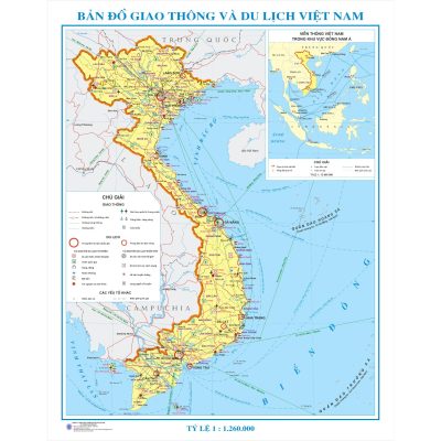
Vietnam is situated on the Indochina Peninsula in Southeast Asia, sharing borders with China to the north, Laos and Cambodia to the west, the Gulf of Thailand to the south, and the Gulf of Tonkin and the East Vietnam Sea to the east. The country stretches 1,650 kilometers in length, with a coastline of 3,260 kilometers that extends from Mong Cai in the north to Ha Tien in the south. The southern region of Vietnam is broader than the northern part.
With its diverse topography, Vietnam offers numerous natural landscapes for exploration, including mountains, hills, deltas, highlands, and beaches. Approximately three-quarters of the country consists of tropical lowlands, hilly terrain, and densely forested highlands. Vietnam experiences a monsoon and humid climate, resulting in varying weather patterns across the north, central region, and south.
The Vietnam travel map features several popular destinations, including Hanoi, Halong Bay, Sapa, Hue, Da Nang-Hoi An, Nha Trang, Da Lat, Mui Ne, Ho Chi Minh City, and the Mekong Delta.
Vietnam is divided into three main regions: the North (the largest area at the top of the S-shaped country), the Central region (the longest and narrowest section in the middle), and the South (the lower part of the country). The northern and western areas are predominantly occupied by mountains and highlands, which create a natural border with China and Laos, covering about three-quarters of the territory.
The highest point, Mount Fansipan, is located in the northwest and is known as the "roof of Indochina," rising to an altitude of 3,000 meters within the Hoang Lien Son range. To explore these regions and their characteristics in detail, refer to the Vietnam tourist map provided here.
The dragon-shaped country also features two deltas at its ends: the Red River Delta in the north and the Mekong Delta in the south. The Red River Delta is known as the cradle of civilization tied to irrigated rice cultivation, while the Mekong Delta serves as the primary "granary" for the country, covering an area nearly three times larger and providing essential grain for the population.
The eastern part of the country features a coastal coastline that stretches over 3,000 kilometers, embellished with numerous bays, beaches, lagoons, and aquaculture areas. Some of the most stunning seaside destinations for swimming, including Nha Trang, Phu Quoc Island, and Con Dao Island, are found in the Central and Southern regions.
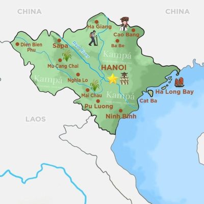
Northern Vietnam is divided into two regions: Northeast and Northwest. This area experiences a temperate climate with four distinct seasons, featuring hot summers and bitterly cold winters, with temperatures in the mountainous regions potentially dropping to 0 degrees Celsius. Keep in mind that typhoons can occur between July and September in the Northern mountainous region, so plan your trip to Sa Pa or Ha Giang carefully during this time.
When visiting Northern Vietnam, you'll have the opportunity to admire stunning rice terraces, majestic mountains, turquoise islets, and vibrant hill tribes. It is also the ideal region to delve into Vietnam’s rich history and culture, as it is home to Hanoi, the capital and heart of the country.
For a memorable experience in this region, consider exploring Hanoi, Halong Bay, Sapa, Ninh Binh, Mai Chau, and Ha Giang.
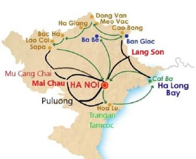
The northern region of Vietnam is characterized by the northern mountains and the Red River Delta, forming the "head" of the country. The northern mountains span two sub-regions: the northwest (the western wing of the north), which includes destinations like Nghia Lo, Mai Chau, Mu Cang Chai, and Sapa. This area is famous for its stunning terraced rice fields that appear to stretch on forever.
Additionally, it is home to Mount Fansipan and the historic battlefield of Dien Bien Phu. Situated near Laos, this region is easily accessible via border crossings such as Tay Trang to Dien Bien Phu or Na Meo. These less-traveled routes allow visitors to experience the extraordinary landscapes and rich cultures unique to this part of Vietnam.
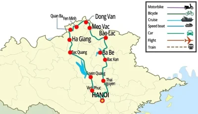
The northeastern and northwestern regions of Vietnam are home to most of the country's ethnic hill tribes. Northeastern Vietnam encompasses the provinces of Tuyen Quang, Thai Nguyen, Phu Tho, Quang Ninh, Ha Giang, Cao Bang, Lang Son, Ban Kan, Bac Giang, as well as the cities of Hanoi and Ninh Binh.

Northwestern Vietnam includes the provinces of Son La, Lai Chau, Yen Bai, Hoa Binh, Lao Cai, and Dien Bien.
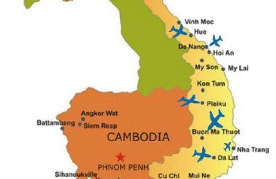
The central region of Vietnam boasts a stunning coastline featuring crystal-clear waters, golden sands, and clear skies, making it an ideal destination for a beach vacation. This area experiences two main seasons: wet and dry, with heavy rainfall typically occurring from September to January. The Central Highlands, which includes Da Lat and Buon Ma Thuot, maintains a cooler climate year-round.
Da Nang serves as the economic and cultural hub of this region. When visiting Central Vietnam, be sure to include Hoi An, an ancient town located just 30 kilometers from Da Nang. Other notable destinations in the area include Phong Nha, Hue, Nha Trang, Mui Ne, and Da Lat.
Tay Nguyen (Central Highlands) is a unique and lesser-known region in Vietnam that remains off the beaten path for many travelers. It comprises five provinces: Kon Tum, Gia Lai, Dak Lak, Dak Nong, and Lam Dong. Known for its cool climate, the Central Highlands offers a refreshing escape from the heat of summer. Additionally, Tay Nguyen is the largest coffee-producing area in the country, so you can enjoy some of the best coffee when visiting Buon Ma Thuot or Gia Lai.
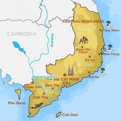
Southern Vietnam enjoys warm weather throughout the year, with average temperatures ranging from 26 to 28 degrees Celsius. This region experiences two main seasons: rainy and dry, with rainfall occurring from May to early November. Although the temperatures can be high, summers in the south are not as humid as in the north, and there are no chilly winters.
When traveling to Southern Vietnam, you can explore the vibrant metropolis of Ho Chi Minh City, known for its lively nightlife, as well as the beautiful beaches of Vung Tau and Phu Quoc, and the exciting Mekong Delta, which is one of Vietnam's two most fertile regions alongside the Red River Delta.
Southeastern Vietnam comprises Ho Chi Minh City, Binh Duong, Binh Phuoc, Ba Ria–Vung Tau, Dong Nai, and Tay Ninh. Southwestern Vietnam, often referred to as the Mekong Delta region, includes 13 provinces: Can Tho, Ben Tre, An Giang, Hau Giang, Tien Giang, Ca Mau, Dong Thap, Long An, Vinh Long, Soc Trang, Tra Vinh, Bac Lieu, and Ca Mau.
To facilitate a smooth travel experience, we provide comprehensive Vietnam visa services, ensuring that your journey to Phu Quoc and other incredible destinations is effortless and enjoyable
We provide fast Vietnam tourist visa services in as little as 1 hour